 Introducing 3D Laser Scanner P40 In India. Please visit
Computer Aided Drawings are the most effective way to document technical drawings and related information in an organized manner. CAD combined with GIS enables data to be analysed geographically. Our CAD outsourcing services are based in INDIA and UAE. We provide complete CAD Conversion services from GIS to CAD format conversion, CAD to GIS format conversion, CAD Drafting, paper to CAD conversions etc. with precision and quality Assurance standards. We assist you, with our leading CAD conversion techniques, to handle, store and maintain information from paper drawings to electronic media and protect these from possible damages or loss of data. Moreover computer aided drawings can also be mapped with geographical co-ordinates through our CAD to GIS conversion techniques. We also offer parcel/cadastral mapping services
CAD DRAFTING AutoCAD drafting CAD Parcel mapping CAD cadastral mapping Documents scanning Contour mapping CAD CONVERSION Paper to Cad Conversion CAD to DGN conversion Multilayer Cad conversion AutoCAD digitization CAD to GIS and GIS to CAD


GIS Services

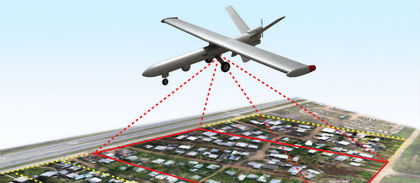
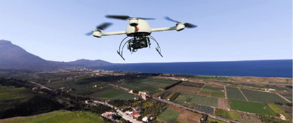
With many years of research and real life experience in all territories of the Geographical Information System (GIS) domain, we provide successful and accurate execution of your GIS related projects. For any research project, the essential and important point with GIS mapping data is registering a map with the correct real world coordinates. If the maps are not georeferenced, no other information can be displayed over or positioned under the map coverage. With our GIS services, we offer accurate georeferencing / geocoding of your projects at affordable prices. We are capable of various geospatial analytical procedures for users in agriculture, transport, electrical network, water supplies, sewage, etc.
GIS services:
- Utility Mapping
- Route Network Analysis
- Digitization/Vectorization
- Water Resources Planning
- GCP Data Capture and analysis
- Topographical and Cadastral mapping
- Image GeoRectification / Georeferencing
- Rural/Urban:Planning,Development&Management